Manikaran-Pin Parvati trek
Region: Manali, Manikaran (Parwati Valley) Pin Pass, Pin valley, Spiti Kunzam Pass And Rohtang pass/Manali.
Season: First Week Of July to End of August.
Max. altitude: 5300m.
No. of days: 14 days
High passes: ‘Over 2 strenuous stages Pin Parvati Pass, Kunzam Pass and Rohtang Pass.
Gradient: In the beginning its about 05 hours drive up to Manikaran Over one gets acclimatized easily generally easy trek except Pin Pass. Difficulties are not there, of course ups and downs. Jerk &jolts.
Grading: A reasonable degree of physical fitness is needed for this trek and a one-day acclimatization at Manali is recommended.
Special interest: Excellent view for photographers, ideal place for nature lovers, best spot for adventure lover, Full of Monastic/ Buddhism culture.
The area of Kullu and Manali
The hauntingly beautiful Kullu district lies in Himachal Pradesh, a tiny hill state in the North of India between north longitude 32-26 and, and east longitude 76-59.To its west lies the Bara Bhangal range of mountains, and to the south west are the peaks are Dhauladhar, separating it from Kangra district.
Kullu Manali is the source of river Beas and its tributaries, the Parvati and the Sainj. On the north east and east lay the Central Himalayan Range and beyond them are the border of Lahaul and Spiti.
The magical region comprises a total area of 1924sq miles, an eighty-mile strech of varying width, running north to south along the western side of the great snow range known as the Mid Himalaya.
Parvati Valley:
The main Kullu valley has numerous side valleys opening into it. The most notable of these is the Parvati valley, Parvati River, which meets the river Beas at Bhuntar, is the biggest tributary of the river Beas. There are more than fifty peaks from 5650m.to 6630m. Enclosed between them together with the Retrain glacier, Dibibokri Glacier, Tosh Glacier, Malana Glacier and Parvati Glacier.
Manikaran: Where the hottest non-sumptuous water springs of the world are situated, is the most popular place to visit and stay? Most of the trekking trails commence from the Manikaran motor head.
Pin Valley:
Pin Valley is formed by the Pin river, which rises on the eastern slopes of Pin- Parvati Pass (3500m.) and meets the Spiti river exactly opposite Lingti village. On the way the Parahio Nala near Pokchung joins it. Parahio valley has several peaks and glaciers and it has been declared as a Nationaf Park. From Pin valley one can cross to the Kullu valley over Pin Parvati Pass; and to the district of Kinnaur via ‘shadarof Pass (5022m.) or Tarikhango Pass BAWA PASS (4866m.). Pin valley is much more rugged and barren than the main Spiti valley.
"Pin Valley National Park- Land of Ibex and Snow Leopard"
Spiti (locally pronounced "Piti"):
The sub-division of Lahaul &Spiti combine to make this trans Himalayan district of the India state of Himachal Pradesh (The abode of snow.) The district headquarters at Keylong in Lahaul, and the administrative seat of Spiti is at Kaza. Spiti is connected to the Lahaul by Kunzum Pass (4590m.) and to the state capital, Shimla, through the district of Kinnaur.
Translated, ‘Spiti' means the ‘middle country -a name obviously given as a result of its ties with both India and Tibet fed by several fast- flowing sub- streams, the river Spiti flows through area and joins with the other mighty river of the region, Sutluj, at Khab. With freckles of green over a dry, weather-beaten face, Spiti is a cold desert where the monsoon never comes. Stark beauty, narrow valleys and high mountains characterize it. A century ago, Rudyard Kipling in Kim called Spiti' a world with in a world" and a "place the Gods live" a description that holds true to the present day.
Day to day description:
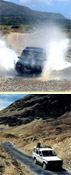
Day 01: Manali - Manikaran 5hrs drive.
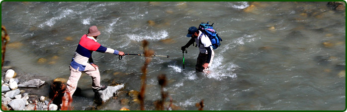
Day 02: Manikaram - Pulga (2791m.) 5hrs. Commence trek from Manikaran after bathing in the hot springs. The distance to Pulga is 18kms. It is an easy trek through narrow valleys accompanied by the constant roar of the river Parvati ‘camp at Pulga amidst green meadows and terraced hill farms besides the river. On the way one can see plenty of hermit pious going on the pilgrimage to Mantalai.
Day 03: Pulga - Khirganga (2960m.) 5hrs. Khirganga means a hot spring water where Lord shiva meditated and done penance. One thing to be potted is that its waterish not like Manikaran and once you have bath your body become greasy whereas in Manikaran as you feel the dryness. This water also contains medical property and treats heart ailments and blood pressure.
Day 04: Khirganga - Tunda Bhuj (3285m.) 5hrs. From Khirganga trek commences through dense forest and flower-strewn meadows, which is an unforgettable experience. The progress is gradual and slow as it is a steep climb unto Tunda Bhuj.
Day 05: Tunda Bhuj - Thakur Kuan (3620m.) 8hrs. After crossing huge rock for 3-4hrs overnight camping in a meadow. Today, onwards one can see lots of water falls, lakes and variety of flowers and large green meadow. It is delighted camping spot.
Day 06: Thakur Kuan - Odi Thach (3800m.) 7hrs. A wonderful trek with a vigorous climb to reach Odi thach.
Day 07: Odi Thach - Mantalai (4070m.) 5hrs. From here one can see Mantalai Glacier, which, is the source of the river Parvati. Here water is gushing out of a massive glacier and then zigzagging its way down the whole valley. It is a world of exhilarating experience. In the middle is the Pandu Bridge, which is made of a single Rock Piece on river Parvati by the Pandavas during their exile in the Himalayas during the Mahabharata Epic. Here you will find numerous varieties of different curative herds growing wild.
Day 08: Mantalai - Base of Pin Pass (4300m.) 7hrs.Today we will ascend to base camp -1 where Mount Parvati will be looking down over you. Camp near the rocky cave or near the plain spotted spaces.
Day 09: Base of Pin Pass - Campsite Over Pin Pass to Base 11 (4110m.) 8hrs. Today steep climb up to the pass (5300m.) and at many places in a zig -zagging way to the top. An Ice axe and rope can prove very helpful. At the top of this slope a large snow filled hollow crevassed leads to the broad rocky saddle of the pass. At the top one can see a splendid fetching view of the snowy mountains of HAMTA REGION likely Deo- Tibba and Indrasan.And one can peep into the Pin valley of Spiti also extensive panorama of several major Kullu and Parvati Peaks.
Day 10: Campsite Over Pin Pass to Base 11 - Tiai (3700m.) 5hrs. Today we trek along the Pin River and little streams to be negotiating. The Government of India has declared pin valley as a National park. It is famous for the Snow Leopard, Musk Deer and Ibex.
Day 11: Tiai - Mud (3650m.) 5hrs. Today we will be trekking through the last village in the Pin valley and the first village via Pin Pass of the Pin valley.
Day 12: Mud - Gulling /Kaza/ Rangrik 6hrs. Walk through the rough road up to the Gulling with grandeur view of the local villages and a barren land of this "Middle country". Jeep will be awaiting at Gulling and drive same day to Kaza. Overnight in camp at Rangrik.
Day 13: Monastic Sights seeing in and around Spiti/Kaza. Today visit KI-Monastery, Kibber village, Dhankar Monastery and Tabo Monastery. Overnight at Rangrik.
Day 14: Rangrik/Kaza - Manali 8hrs. Drive back to the foot of the Kunzum Pass and drive up to the top, which provides the main approach to Lahaul from Spiti. And over at the foot of the pass the last village of Spiti valley is welcomes a small hamlet Losar (4079m.) with a couple of Houses. Stop for a while, get checked your passport. Spiti valley is formed by the Spiti River, which rises on the slopes of Kunzum Pass and ends at the river's confluence with the Pare Chu near Sumdo is about 150km. Over Kunzum pass to Batal, after that it starts the real drive up to
Chotadara, Chhtru and Grampoo through the rugged and Chandera river valley. On the way left
Hand side is Bara Shigri glacier. Bara meaning big and Shigri meaning glacier in Spitiand dialect. The Glacier is mountainous mass of solid ice, more than a kilometer wide and extending over a distance of ten kilometers. At Grampoo it divides the valley into Lahaul &Spiti. And turns right hand side at Grampoo towards Lahaul & Leh and left hand side turn to the Rohtang/Manali. At Grampoo the real climb to Rohtang Pass, Here one sees the majesty of the mountains at its height and splendid. At the top of the Pass the air seems to glitter against the snow as you look down over herringboned ridges into the Lahaul valley. A few kilometers away from the Pass is Sonapani glacier: slightly to the left are the twin peaks of the Gepan jagged pyramid of rock and snow crowned. And slowly descend down to over Rohtang Pass to Manali. Overnight in hotel at Manali.
Trek concluded.
Day 15: Departure Manali - Delhi